|

|

Plot Land |

Search Alberta Corporate Registry |

Search Edmonton Property |
 Android |

Links |
|
Cowichan Land Ruling |
GeoJSON Cheat Sheet
What is GeoJSON?
GeoJSON is an open geospatial data interchange format based on JavaScript Object Notation (JSON).
GeoJSON uses World Geodetic System 1984 (WGS84), with latitudes and longitudes in positive/negitve decimal degrees. WGS84 is the standard for GPS.
GeoJSON defines JSON objects and a syntax to represent data about geographic features, their properties, and their spatial extents.
The GeoJSON objects include:
- points (addresses and locations),
- line strings (streets, highways and boundaries),
- polygons (countries, provinces, tracts of land), and
- multi-part collections of these types.
What is JSON?
JavaScript Object Notation (JSON) is a lightweight, text-based, language-independent data interchange format.
It was derived from the ECMAScript Programming Language Standard.
JSON defines a small set of formatting rules for the portable representation of structured data.
GeoJSON Types
- Point
- LineString
- Polygon
- MultiPoint
- MultiLineString
- MultiPolygon
- Geometrycollection
- Feature
- FeatureCollection
ESRI Shapefile (*.shp) Types
#define SHPT_NULL           0
#define SHPT_POINT          1
#define SHPT_POLYLINE       3
#define SHPT_POLYGON        5
#define SHPT_MULTIPOINT     8
#define SHPT_POINTZ        11
#define SHPT_POLYLINEZ     13
#define SHPT_POLYGONZ      15
#define SHPT_MULTIPOINTZ   18
#define SHPT_POINTM        21
#define SHPT_POLYLINEM     23
#define SHPT_POLYGONM      25
#define SHPT_MULTIPOINTM   28
#define SHPT_MULTIPATCH    31
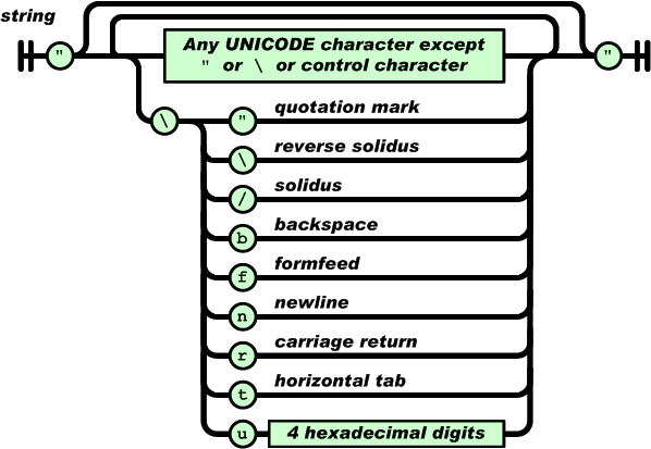
Escaping Special Characters in JSON / GeoJSON

| Special character | Escaped output |
|---|---|
| Quotation mark (") | \" |
| Backslash (\) | \\ |
| Slash (/) | \/ |
| Backspace | \b |
| Form feed | \f |
| New line | \n |
| Carriage return | \r |
| Horizontal tab | \t |
| HEX (4 digits) | \uXXXX |
Example of a Dominion Land Survey (DLS) Section in GeoJSON
{
   "success" : true,
   "type": "FeatureCollection",
   "features":
    [
       {
         "type": "Feature",
         "properties":
         {
            "TITLE":       "10-51-23-W4",
            "LATITUDE" :     53.38844354,
            "LONGITUDE":   -113.30751230,
            "NORTH":         53.39568232,
            "SOUTH":         53.38120475,
            "EAST" :       -113.29534775,
            "WEST" :       -113.31967684,
            "ZOOM": 14,
            "FILE_NAME": "423051",
            "TRM": "051234",
            "RGE": 23,
            "TWP": 51,
            "SEC": 10,
            "RA": "",
            "DESCRIPTOR": "SEC-10 TWP-051 RGE-23 MER-4",
            "PID": "423051100"

         },
         "geometry":
         {
            "type": "MultiPolygon",
            "coordinates":
            [
               [
                  [
                    [-113.29534887,53.38481764],
                    [-113.29534775,53.38120475],
                    [-113.30142060,53.38121331],
                    [-113.30749346,53.38122157],
                    [-113.31356631,53.38122954],
                    [-113.31963915,53.38123720],
                    [-113.31964855,53.38483459],
                    [-113.31965792,53.38843196],
                    [-113.31966739,53.39205714],
                    [-113.31967684,53.39568232],
                    [-113.31359568,53.39567596],
                    [-113.30751452,53.39566928],
                    [-113.30143338,53.39566229],
                    [-113.29535225,53.39565498],
                    [-113.29535112,53.39204276],
                    [-113.29534998,53.38843053],
                    [-113.29534887,53.38481764]
                  ]
               ]
            ]
         }
       }
    ]
}
References
-
Bing Maps: Using GeoJSON
Creating and Hosting a map
Microsoft
-
Bing Maps: Read GeoJSON object and plot
Reads from a GeoJSON string and renders it as a polygon on a Bing maps
Microsoft
-
Bing Maps: Getting a Bing Maps Key
As of April 2023, there are rather generous usage limits on the Basic (Free) Account
Microsoft
-
Using GeoJSON with Leaflet
Leaflet is an open-source JavaScript library for mobile and desktop interactive maps
by Volodymyr Agafonkin
-
OpenLayers GeoJSON Example
OpenLayers is an open-source JavaScript Library released under the 2-clause BSD License
NOTE: We have used Bing and Leaflet, but we have not tried Openlayers.
-
RFC7946
The GeoJSON Format
-
RFC8259
The JavaScript Object Notation (JSON) Data Interchange Format
-
GeoJSON Viewer & Validator
Online 3rd Party Lint Checker for GeoJson
https://geojsonlint.com
-
How to Escape Special Characters in a JSON String
Stack Overflow
-
US Library of Congress
Recommended Formats Statement
Geographic Information System (GIS) - Vector Data - Salesforce: Apex Developer Guide Pages Salesforce is a popular Customer Relations Management (CRM) platform.


