|
|
 for Legal Land Converter")
|

Plot Land |

Search Alberta Corporate Registry |

Search Edmonton Property |

Draw Canada Topo Map |

Search Edmonton Building Permits |
 Android |

Links |
Use Encrypted Site https://legallandconverter.com/

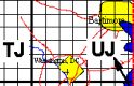
Find land in Western Canada (British Columbia, Alberta, Saskatchewan & Manitoba) subdivided by the Dominion Land Survey (DLS) and the Alberta Township System (ATS).
Legal Land Description to Latitude and Longitude,
GPS, UTM, NTS & MGRS.
Example:
SW 24-12-20-W4
Southwest Quarter of Section 24,
Township 12, Range 20, West of the 4th Meridian.
Latitude and Longitude to Land Legal Description
Example:
Latitude 50.00820
Longitude 112.61440
Examples:
50° 00' 29" N
112° 36' 51" W
50° 00.49' N
112° 36.86' W
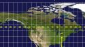
Area Covered by the Dominion Land Survey

Locate farms, forest, fields, acreages, oil and gas wells, leases, Legal Subdivisions (LSD), Unique Well Identifiers (UWI), mineral rights, surface rights, timber, mines, cabins, trap lines & fishing spots in the Prairie Provinces & BC.
00000

Setting up an Account