|
|
 for Legal Land Converter")
|

Plot Land |

Search Edmonton Property |
 Android |

Links |
|
Cowichan Land Ruling |
|
Live CSRD Property Query with Boundaries plotted on Latest MapBox Imagery |
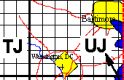
Canadian Federal Permit System
FPS to Latitude and Longitude
Yellowknife
38 62-30 N 114-15 W
Hay River
F 72 61-00 N 115-30 W
Latitude and Longitude to FPS
Yellowknife
Latitude 62.464583
Longitude -114.355469
Hay River
Latitude 60.856250
Longitude -115.738281
Yellowknife
62° 27' 52.50" N 114° 21' 19.69" W
Hay River
60° 51' 22.50" N 115° 44' 17.81" W


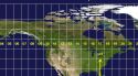
The Canadian Federal Permit System is the Land Division System used by the Canadian Federal Government to regulate oil and gas exploration in Federal Lands in Canada.
It covers the
- Northwest Territories (including offshore)
- Nunavut (including offshore)
- Atlantic Ocean (offshore Maritimes)
- Pacific Ocean, (offshore British Columbia)
- Hudson Bay
Each grid is know by the latitude and longitude of it's North East corner.
References
-
Naming Process for Federal Permit System (FPS) Survey Grids and Wells
National Energy Board
Government of Canada