|
|
 for Legal Land Converter")
|

Plot Land |

Search Edmonton Property |
 Android |

Links |
|
Cowichan Land Ruling |
|
Live CSRD Property Query with Boundaries plotted on Latest MapBox Imagery |
Legal Land Description FAQ
What Coordinate System is used?
WGS84 is used for all coordinates. It is the what GPS uses.
What is the ATS?
The Alberta Township System (ATS) is a variant of the Dominion Land Survey (DLS) system as implemented in Canada. The ATS is a grid network dividing the province into equal-sized square parcels of land, for purposes of administering legal land title.
The ATS designates land as being west of the 4th Meridian (110 degrees west longitude), 5th Meridian (114 degrees west longitude) or 6th Meridian (118 degrees west longitude). Between meridians are a series of columns, each six miles wide, called ranges. They are numbered consecutively from east to west, beginning west of the meridian. Townships are also six miles wide and are numbered from south to north. The southern Alberta border with Montana is township 1, up to the northern border with the Northwest Territories at township 126.
"Township" also describes the six mile by six mile square formed when the range and township lines intersect. These townships are further divided into 36 sections, each measuring one mile by one mile (one square mile). One section contains 640 acres. A section can be further divided into quarters (NE, NW, SE, SW) of 160 acres each or into 16 legal subdivisions (LSDs).
Legal land descriptions are written as in the following example:
SW 24-38-20-W5
Southwest Quarter of Section 24, Township 38, Range 20, West of the 5th Meridian.
What is the History of the
Dominion Land Survey System?
The Dominion Land Survey System laid out nearly uniform land parcels that can be precisely described and located in the settled areas of the four western provinces.
This system was designed to describe essentially agricultural land areas in an understandable and detailed manner down to ten acres (4 ha) in size. Cities, First Nations reserves, federal parks, the older river lots, and lands that were Hudson's Bay Company posts were excluded from the survey. The system was based on a model used in the mid-western United States. Both plans used a one square mile land unit. The Canadian system was modified from the US system to exclude road allowances from the land to be used for agriculture. In Canada there were five variations in the system, largely related to roadway accommodation and how the convergence of the lines of longitude was handled.
Difficulties in mountainous terrain and the overlapping of a flat grid system meant that only small portions of British Columbia were surveyed under the system. Almost all the settled areas of Manitoba, Saskatchewan, and Alberta were, however, surveyed and remain under the original land description system, except for the local areas already mentioned as being outside this system. When urban areas were being created, a new plan was laid over the original survey; and where this occurs, the city or town type of survey using blocks and lots prevails.
The basic system was a grid. The major grid boundaries comprised of township lines paralleling the lines of latitude, and of a system of range lines largely paralleling the lines of longitude. Within these east-west and north-south grid lines, which occur about every six miles (six miles plus road allowances) are divisions creating blocks of land called sections, as near as possible to one mile by one mile square, i.e., 640 acres or close to 259 ha.
These sections are subdivided into quarters, and on occasion the sections may have been subdivided into legal subdivisions and quarters of legal subdivisions. The quarters contained more or less 160 acres (about 65 ha), and the legal subdivisions were sixteen per section or forty acres (16 ha) each. The townships, ranges, sections and legal subdivisions are numbered, while the quarter sections and quarters of legal subdivisions are identified by their compass location, i.e., the southwest, southeast, northwest and northeast quarters within a section. Townships are numbered consecutively from the United States border northward, and ranges are numbered westward from each meridian. There are range lines at the prime meridian just west of Winnipeg, and thereafter at each meridian. The second range line is at 102 degrees west longitude, and then every four degrees of longitude to the west. This allows identification of land parcels when the legal land description is known and understood.
The legal description of land follows a set sequence of quarter section, township, range, and meridian: the designation NW 27-9-25 W2, for instance, means the Northwest Quarter of Section 27 in Township 9 Range 25 West of the Second Meridian. In the original survey marker pegs were set out on the quarter sections, and these survey stakes contained the land identification cut into them in Roman numerals.
The system was implemented on July 10, 1871, in Manitoba and continues to be used in more isolated areas. The survey was carried out in advance of the western movement of settlement. For instance, the Saskatchewan area survey began in 1877, Alberta in 1881, and a small area near New Westminster, British Columbia in 1874.
What is the PLSS system?
The public land survey system is most often used on topographic maps published in the United States and has its roots in the early surveys of North America in the 1700s. The PLS system differs from other coordinate systems in that it is more descriptive and relies less on absolute measurements of location. It is useful in that it is a good way to give a quick approximation of a location, but the main drawback is its lack of accuracy.
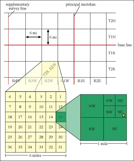
In each state (with the exception of the original thirteen and some states in the southwest that were originally surveyed based on Spanish land grant boundaries) early surveyors established a principle meridian running north-south, and a base line running east-west. These initial survey lines served as a basis for subsequent survey lines spaced at 24 mile intervals along the eastern, western, and southern boundaries. Further subdivision of these "squares" led to the creation of 16 smaller squares measuring six miles on a side. When measuring in a north-south direction, each of these squares is called a township. When measuring in an east-west direction, each of these squares is called a range. So, a 36 square mile area located between six and twelve miles east of the principle meridian and twelve to eighteen miles north of the base line would be called township three north, range two east (written as T3N., R2E).
Each township is further subdivided into 36 smaller squares covering roughly 1 square mile. These areas are called sections and are numbered within a township from the upper right to the lower right in an alternating manner (1 to 6 are numbered from left to right, 7 to 12 from right to left, etc.). These one mile squares are the smallest formal subdivision in the PLS system, however, to describe a location the squares are quartered, and then the quarters are quartered as shown below. The location of the star in the figure below would be described as the southeast quarter of the southeast quarter of the northeast quarter, section thirteen, township two south, range two west. The shorthand for this is: SE1/4, SE1/4, NE1/4, sec. 13, T2S., R2W.