|
|
 for Legal Land Converter")
|

Plot Land |

Search Edmonton Property |
 Android |

Links |
|
Cowichan Land Ruling |
|
Live CSRD Property Query with Boundaries plotted on Latest MapBox Imagery |
Military Grid Reference System
MGRS / USNG to Latitude and Longitude
Example:
12U UA 84323 40791
12U UA 84 40
Street Address to MGRS
Latitude and Longitude to MGRS / USNG
Example:
Latitude 50.00820
Longitude -112.61440
Example:
Latitude 50° 00' 29.52" N
Longitude 112° 36' 51.84" W
United States National Grid (USNG) - Grid Zone Designations (GZD)
 - Grid Zone Designations (GZD)")
USNG Map with 6 x 8 Degree Grid Zone Designators
 Index Map with 6 x 8 Degree Grid Zone Designators")
United States National Grid Index Map in PDF
United States National Grid Page at Federal Geographic Committee

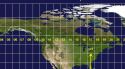
World Map with MGRS Grid
(*) Get GPS Location Button
When supported, clicking this button automatically fills in your current Latitude and Longitude within a few seconds.
When not supported, clicking the button does nothing.
The best accuracy (within about 10 meters) is obtained on devices with a built in GPS chip such as smart phones which can directly receive satellite GPS signals.
On devices without a GPS chip, Latitude and Longitude are guesstimated by Google based on your IP address and the known locations of the nearest WIFI access points and their addresses.
GPS reception in downtown Edmonton can be as much as 40 meters off, due to intereference from tall buildings, which can put you behind the building in a sketchy alley, instead of in front of the fancy front doors on Jasper Ave (Main Street Edmonton).
NB: Please check that the 'Get GPS' button works before you leave the office.
Today's security protocols turn GPS off by default and it can be very difficult to turn back on while in the field. Trouble shooting while in a moving vehicle with bad internet access while the driver is asking for directions is not fun.
The Pixel 6a we tested on had four layers of settings that needed to be turned on for 'Get GPS' to work. These 4 layers of settings are: 1) The chip, 2) the os, 3) the app and 4) the webpage.
We reccommend that test your phone to "get gps location" first, in the office, with a desktop computer handy, with access to google search and with tech nerds about.
References
-
The UTM Grid - Civilian UTM Grid Reference
Natural Resources Canada