|
|
 for Legal Land Converter")
|

Plot Land |

Search Edmonton Property |
 Android |

Links |
|
Cowichan Land Ruling |
|
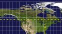
Live CSRD Property Query with Boundaries plotted on Latest MapBox Imagery |
Application Programming Interface
Access
- Both API's are accessible via POST and GET methods.
- Both API's are accessible via http:// and https://
Android API
Documentation for the Android APIConversions for DLS, PLSS, NTS and MGRS
This API started out as the backend for our Android java app, but has grown into a robust high-volume API that stands on it's own.
The results are easy to parse in any computer language -- eliminating a 3rd party library parser dependency in your long term code base.
GeoJSON API |
|||
| • | DLS | Canada | Dominion Land Survey |
| • | NTS | Canada | National Topographic System |
| • | FPS | Canada | Federal Permit System |
| • | PLSS | US | Public Land Survey System |
GeoJSON is a data standard and is in the list of data formats by the Library of Congress recommended for long term data storage.
See our GeoJSON Cheat Sheet for information and reference links on the GeoJSON data format.
Modern Web Browsers do not allow XMLHttpRequest(); to request pages from another domain.
To incorporate GeoJSON results from legallandconverter.com, configure your web server to use a web proxy.
Using a Web Proxy for Cross Domain Scripting