|
|
 for Legal Land Converter")
|

Plot Land |

Search Edmonton Property |
 Android |

Links |
|
Cowichan Land Ruling |
|
Live CSRD Property Query with Boundaries plotted on Latest MapBox Imagery |
Universal Transverse Mercator (UTM)
UTM to Latitude and Longitude
Example:
12N 384323 5540791
Latitude and Longitude to UTM
Example:
Latitude 50.00820
Longitude 112.61440
Examples:
50° 00' 29" N
112° 36' 51" W
50° 00.49' N
112° 36.86' W
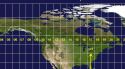
World Map with UTM Grid

Universal Transverse MercatorUniversal Transverse Mercator (UTM) is a coordinate system that maps the Earth's round surface onto a relatively accurate flat two dimensional surface.UTM does this by dividing the Earth into small squares. These squares are 6 degree wide "Zones" of longitude and 8 degrees tall "Bands" of latitude except for Band 'X' which is 12 degrees tall. Zones are numbered 1 to 60, run left to right, west to east and correspond to the 'X axis' on a cartesian graph. Zone 1 starts at 180° West longitude and Zone 60 ends at 180° East longitude. Zone widths are uniform over the globe, except on the southwest coast of Norway and the region around Svalbard. Bands are labeled C to Z, run bottom to top, south to north and correspond to the 'Y axis' on a cartesian graph. Letters "I" and "O" are not used for band labels to avoid confusion with the numbers one and zero. Bands "C" starts at 80° South latitude and Band "X" ends at 84° North latitude. Easting and Northings are in meters. Eastings increase eastwards and decrease westwards. Eastings are referenced from the called the Central Meridian The Eastings start at the Central meridian at the number 500,000 (called the False Easting), not zero, thus eastings are never negative numbers.// The Central meridian is 3 degrees west of the eastern border of the Zone CentralMeridian = ( zone - 1 ) * 6 - 180 + 3; Northings are referenced from the Equator. Northings increase northward and decrease southward. Northings run from 0 to (almost) 10,000,000 which is (very close to) one quarter of Earth's polar circumference of 40,007,860 meters. Northings for the Northern Hemisphere start at the Equator from 0 and increase northwards to 9,328,195 at 84°N latitude. Northings for the Southern Hemisphere start at the Equator from 10,000,000 and decrease southwards to 1,118,248 at 80°S latitude;
Examples:
   A point south of equator with a northing of 7587834 is:
      10,000,000 – 7587834 = 2412166 meters south of the equator.

  A point 34m north of the equator has a northing of 0000034
  A point 34m south of the equator has a northing of 9999966
LongOrigin = (UTMZone - 1) * 6 - 180 + 3; Convention 1 :: Zone Number -- Band Letter (eg. 12U) In this convention, a Zone Number is followed by a Band Letter and is used to identify each 6 x 8 grid. They are working with maps of this size. Convention 2 :: Zone Number followed by 'N' or 'S' (eg. 12N) In this convention, a Zone Number is followed by an 'N' for the Northern Hemisphere or 'S' for Southern Hemisphere. The concern here is locating the land.
|